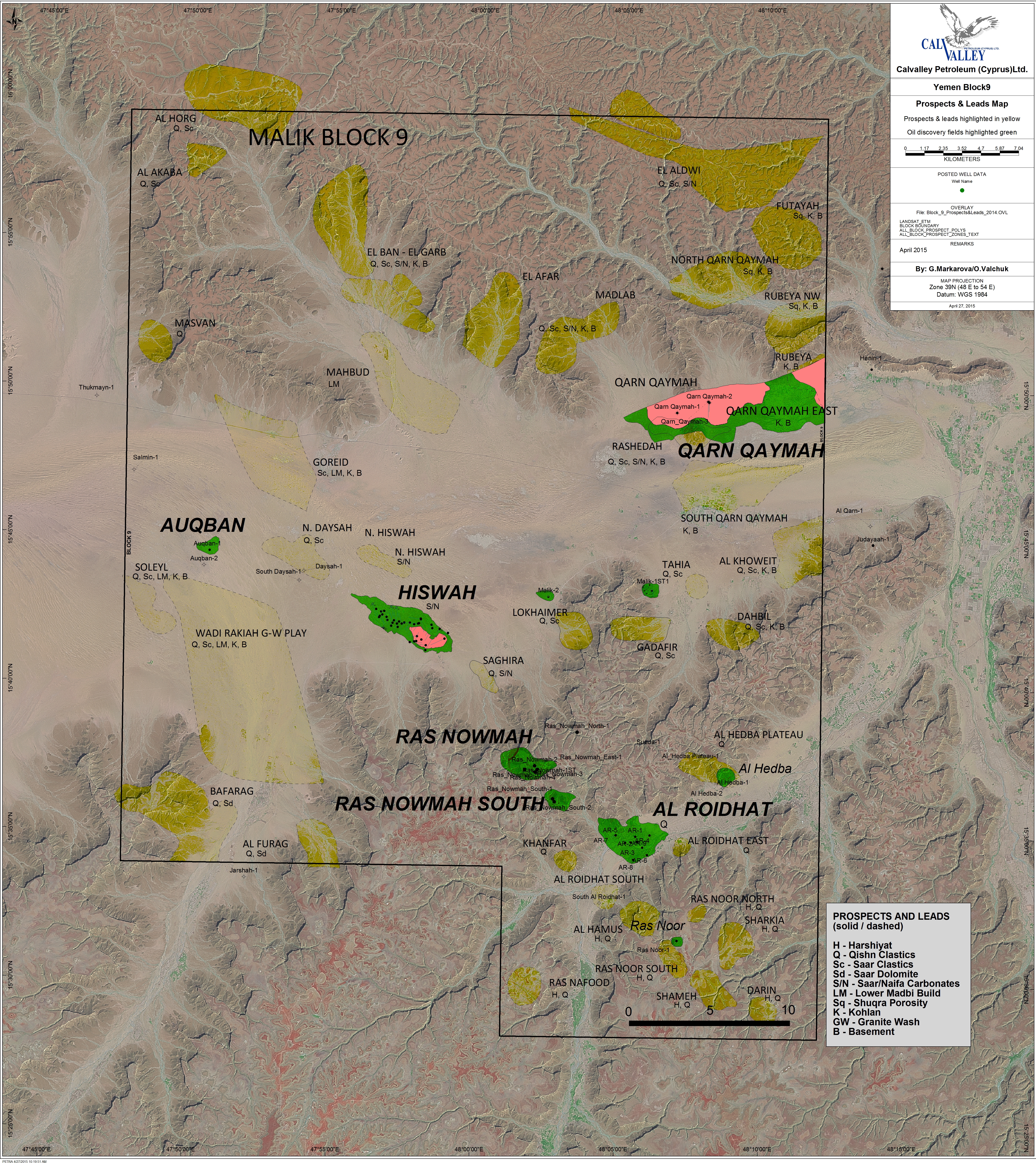
Yemen Project (Block 9) Exploration
Block 9 resides within the prolific Sayun-Masila geologic basin that is recognized to have attractive hydrocarbon source-reservoir-seal combinations. Calvalley’s success in Block 9 is a direct consequence of these attractive characteristics and additional exploration is being planned to build upon this early success. Figure 1 shows the Sayun-Masila basin and Block 9 in west-central Yemen.
Figure 1–The tectonic framework map for western Yemen showing the Malik Block 9 in the important Sayun-Masila basin, as well as the prolific Masila Block 14 operated by Nexen, located east of Block 9.
The generalized stratigraphic column for Block 9 is shown in Figure 2 and identifies the different oil-bearing horizons that have been discovered to date. The Madbi source formation is responsible for generating all the oil in this basin and migration is facilitated by normal faulting.
Figure 2–The generalized stratigraphic column for Block 9 which can be applied to the entire Sayun-Masila basin. The important Madbi formation is identified as well as the discoveries drilled to date.
There are three separate basins that can generate oil in the vicinity of Block 9 and all exist within the ‘oil-window’ of source-rock maturation. The main Al Qarn sub-basin, shown in Figure 3, below, is the dominant source basin in Block 9 and is also responsible for generating the gas-condensate that was discovered at Qarn Qaymah. From an exploration perspective, these are large basins that minimize risk of charge.
Figure 3–The reservoirs in the subsurface of Block 9 can be charged from three different sub-basins, while the main Al Qarn Sub-Basin may be responsible for the majority of oil generation.
Exploration continues to play an integral role in capturing the potential upside of Block 9. While early production and development drilling progresses, exploration activity is concurrent with both drilling and seismic acquisition being conducted. During 2006 a 760 km seismic program intended to advance the evaluation of earlier identified leads, as well as to identify additional leads. The majority of the leads in Block 9 are associated with large-relief basement fault blocks and have multiple prospective horizons. The structures are offset by source-rock basins that are responsible for charging the structures.
The maps below (Figures 4 & 5) are a summary of the existing leads and prospects presently identified with the existing seismic database. The 2006 seismic acquisition is shown by the red lines on the adjacent map.
Figure 4
Figure 5
Block 9 leads and Prospects Map plus Proposed 2006 Seismic Acquisition. The blue areas represent the Yemen plateau and the white areas the wadis (valleys).
Block 9 covers Wadi Hadramut, a major valley that is surrounded by plateau. The photograph below (Figure 6) shows the contrast in elevation between the wadi and the plateau areas in Block 9.
Figure 6
The example seismic section below (Figure 7) shows the attractive play types available to Calvalley in Block 9. The basement horst blocks are evident in the southwest part of the line, with the stratigraphic column pinching out against and draping overtop the highs. The reservoirs are charged from the Madbi source rock and migration occurs laterally and via faults into sealed traps.
Figure 7–Seismic line across Wadi Hadramut showing the basinal low areas and structurally high, prospective areas.
To date Calvalley has identified over twenty prospects and leads in Block 9 and each has multiple prospective horizons. Calvalley plans to pursue exploration targets throughout the early development of the Block and a single new success could result in a reappraisal of the surface facility requirements for additional export volumes.